
Getting around a metropolitan city can be overwhelming, even for the city dweller. Managing frequent train delays and erratic bus departures requires patience and a crystal ball. Neither of which I have! So identifying a reliable and economical transportation app is my number one priority, or it use to be, until I found City Mapper.
I found Citymapper through a simple search in the Android App store. Last year, before a weekend trip to New York City I decided to download a subway map. I searched the Android app store for “New York subway map” and Citymapper was the first result. To protect my phone from probable malicious software, I followed general safety procedures I reviewed the comments, images, features, and the number of downloads before downloading. After one weekend I knew I had found my new favorite app. It surpassed mine and my friends’ expectations with its facility, accessibility, and features. While there are more than ten reasons that I love Citymapper, I decided to keep this list to a reasonable number.
 10- Free
It’s free. (Yeah, your favorite word!) It is free to download and use. No hidden premiums.
9- Calorie counter
Don’t let any calorie burning go to waste. For those of us without a FitBit HR. Citymapper provides a basic calorie counter for walking and biking. It provides a general idea of how many calories the average person will burn. For example, walking 1.5 miles will burn 140 calories the equivalent of 0.7 of a Grande half-cafe semi-skim latte.
 8- Bus routes
It’s easier to find a subway map than it is a bus route map. Now try finding an interactive map, one that will follow along your trip or allow you to visually see the route and connecting cross streets. Try. Not so easy. Citymapper’s bus route maps are viewable as a list or on a map. Double tap a stop for real-time arrivals and the schedule.
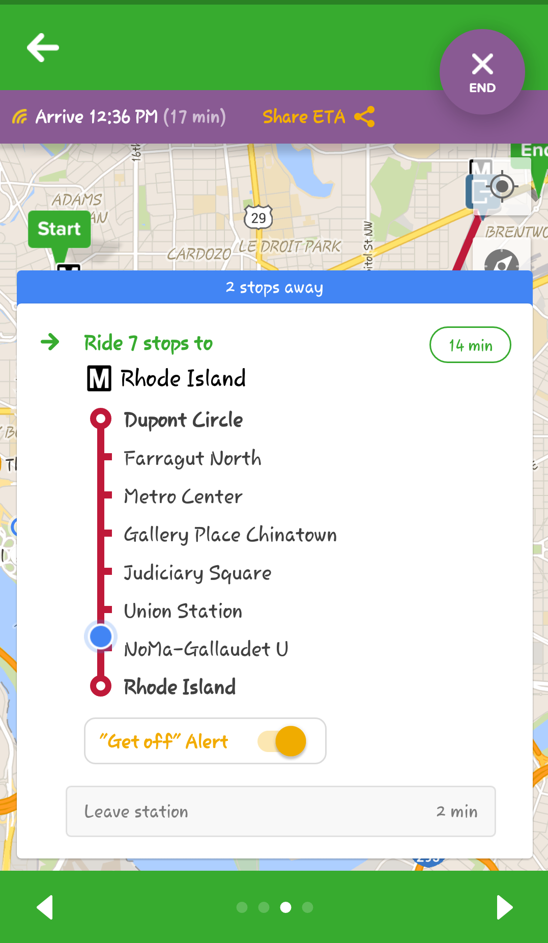
7- Notifications
I don’t know about you, but I hate missing my stop. Just a few months ago, Citymapper automated the notification feature. Previously, once you started your trip you could set-up stop notifications, which would go off two stops before it was time to get off the bus or train. Now you can sit your phone down, play Angry Birds, text a friend, daydream, or whatever you want and just wait for the notifications.
6- Meet Me Here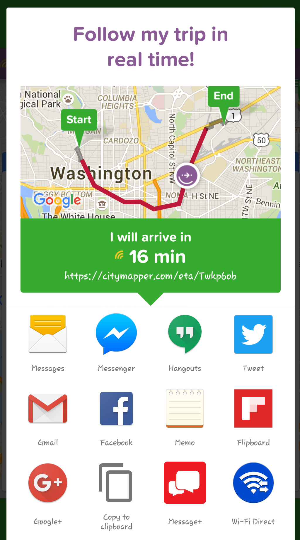
Do frequent texts of, “Where are you?” or “When are you going to get here” annoy you? If not stop here and move to number 5. If the answer is yes, keep reading. Citymapper lets you share your trip information via social media and email. Just hit “Share” from the trip and let Citymapper do the rest.
5- Smart Commute
In February of 2016, Citymapper added a new feature called Smart Commute. This new feature takes the app to a whole new level. Instead of running a trip plan every morning, the app will do it for you automatically. Simply set-up notifications to indicate what time the app should start and stop generating a trip plan. The only reason I stopped using it was because it kept reminding how late I was for work.
4- Numerous route options
Google maps is effective but the available route options are limited. Any large city has at least four modes of transportation. Citymapper, however, integrates every possible mode of transportation, which allows an even higher number of combinations. They even provide all bus routes and rain routes.
3 – Real-time Feeds
Numerous route options are helpful. But what you really want is real time updates on arrival, delays, reroutes, and cancellations. When the train is delayed, which happens frequently in DC, it is helpful to have the various official Twitter channels on hand. Now, I’m able to scan what the company is saying at glance and then switch to my personal Twitter to see what passengers are saying.
2- Where to Get on the Train
Position is everything. Getting on the right train car can mean the difference between making or missing your connection. With Citymapper’s “Where to Get on the Train” feature, there is no more guesswork.
1- City Maps From Around the World
Now if ten through two aren’t enough, maybe maps from around the world will be. Yeah, around the world! Asia, Europe, South America, Latin America, and the United States. As a traveler finding an app that I can take (almost) anywhere is necessary. When I learned that Citymapper provides a consistent level of service in most major cities, I had to have it.
Now I love this app and recommend it all the time, but there are a couple of things I’d like to see:
- How much do the different route costs? It provides estimates for taxis, Uber, and Car2go, but not the rest of the options.
- Mexico City is in Spanish. Unfortunately, I don’t read Spanish, so while I’m excited to have access to the city I’m bummed that I can’t read the map.
My hack to you –
If you travel for work or fun download this app! If it doesn’t make your life better tell me and if it does tell. And tell Citymapper they are always asking for feedback.